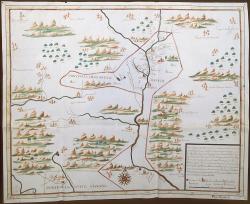
Map of New Mexico, 1727
From the exhibition:
El Hilo de la Memoria: Espa±a y los Estados Unidos
New Mexico History Museum
Map of New Mexico by Francisco Alvarez Barreiro, January 12, 1727
Chorographic or regional plan of the kingdom and province of New Mexico belonging to New Spain. Barreiro participated in the inspection done by Brigadier Pedro de Rivera and Villalón between 1724 and 1728.
Manuscript, gouache in brown, green, blue, and red, parchment.
Sevilla. Archivo General de Indias. MP-México, 122.
Note: Representative image at left is often cropped for display purposes. Downloaded high-resolution images are not cropped.
